
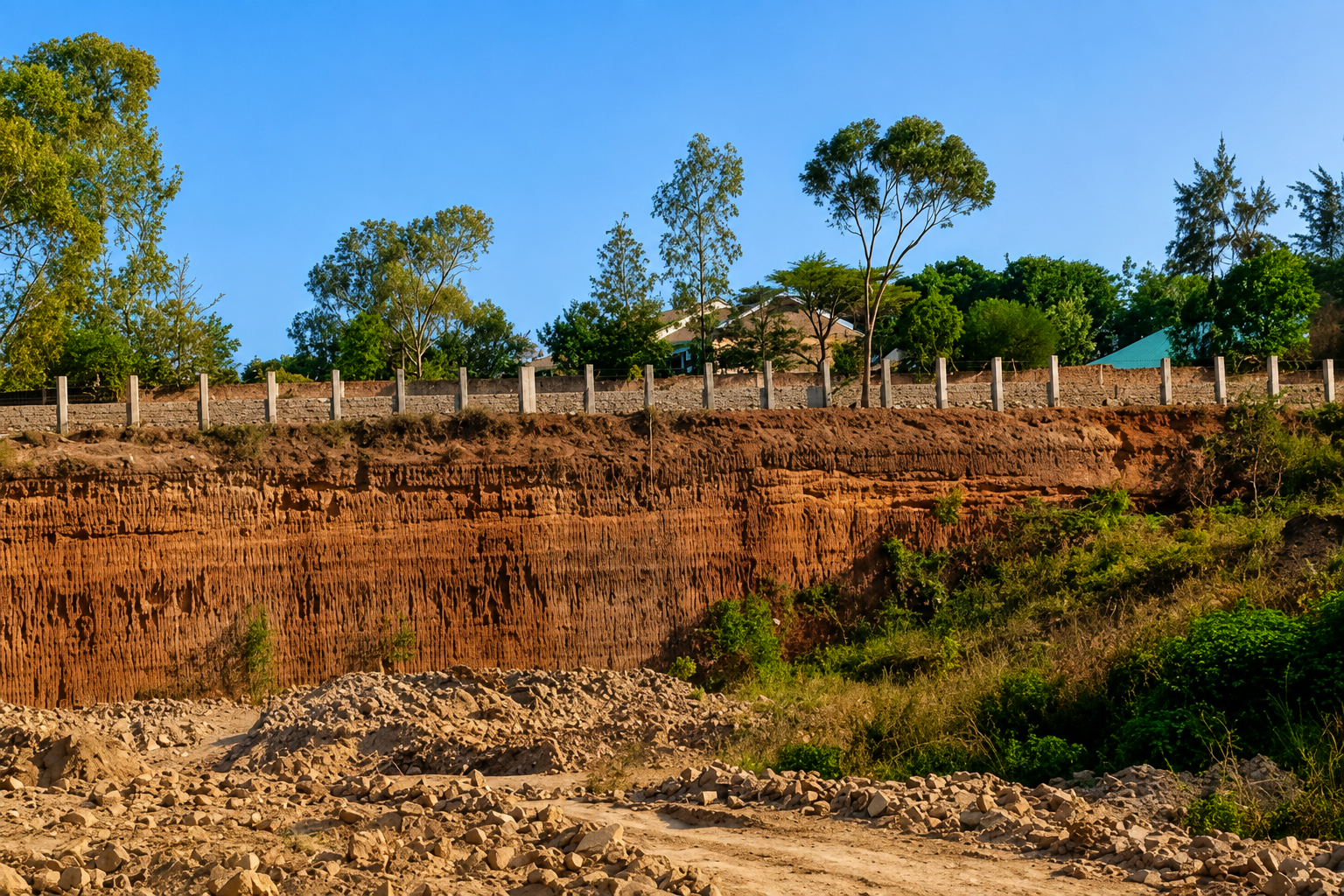
Planning Safe and Livable Post-Quarry Environments in Kenya
Across many urban and peri-urban areas in Kenya, former quarry sites remain as dangerous voids in the built environment. What once served as productive extraction sites often becomes abandoned land with deep pits, unstable edges, exposed rock faces, stagnant water, poor access control and no clear plan for future use.
In areas such as Ndarugu in Juja, Kiambu County, and other rapidly growing peri-urban settlements, disused quarries can quickly become safety, environmental and planning concerns. Water-filled pits may expose nearby communities, especially children, to drowning risks. Unstable quarry edges can collapse without warning. Poorly secured sites may attract unsafe activities, illegal dumping or informal uses that increase public health and security concerns.
Yet these same quarry sites also present an important planning opportunity. With the right technical studies, land use planning and environmental rehabilitation strategy, exhausted quarries can be transformed from hazardous spaces into safe, functional and productive environments that support housing, recreation, commerce, ecological restoration and better urban form.
Post-quarry land regeneration is not simply about filling a pit or assigning a new land use. It is a careful process that requires physical planning, environmental assessment, geotechnical investigation, infrastructure planning, stormwater management and community engagement.
Why Post-Quarry Planning Matters
Former quarry sites are different from ordinary vacant land. They have been physically altered through excavation, extraction, blasting, cutting, loading and material removal. As a result, the land may have changed in slope, structure, drainage, stability and environmental character.
Without proper planning, these sites can remain:
- Dangerous to surrounding communities
- Difficult to develop safely
- Vulnerable to flooding and ponding
- Environmentally degraded
- Disconnected from surrounding neighborhoods
- Attractive to illegal dumping or unsafe activities
- Underutilized despite being located in strategic urban growth areas
A well-prepared post-quarry land use plan helps convert these risks into opportunities. It guides how the land can be reclaimed, stabilized, serviced and reused in a way that protects people, supports development and improves the surrounding urban environment.
Common Risks Found in Abandoned Quarry Sites
Before any post-quarry development is proposed, the site must be studied carefully. Many abandoned or exhausted quarries contain physical and environmental risks that are not always visible from the surface.
Common risks include:
Unstable Quarry Faces
Steep quarry walls and exposed rock faces may become unstable over time. Cracks, loose joints, weathering and unsupported slopes can increase the risk of collapse.
Deep Excavations
Large quarry pits can create dangerous drops, especially where there are no barriers, fencing, warning signs or controlled access points.
Water-Filled Pits
Quarry depressions often collect rainwater and runoff. These water bodies may appear harmless, but they can be deep, unsafe and difficult to rescue people from.
Poor Drainage and Flooding
Quarrying can disrupt natural drainage patterns. Former quarry sites may experience ponding, flooding or uncontrolled stormwater movement if drainage is not properly planned.
Exposed Rock and Weak Platforms
Not every part of a former quarry can support buildings, roads or public facilities. Some areas may require stabilization, filling, compaction or restricted use.
Environmental Degradation
Past extraction may leave behind dust, bare surfaces, poor vegetation cover, waste materials or disturbed habitats that require rehabilitation.
Post-Quarry Land Is Not Ordinary Vacant Land
One of the biggest mistakes in post-quarry development is treating an exhausted quarry as a normal open plot. This can lead to unsafe design decisions, unrealistic development expectations and long-term risks.
A former quarry must first be understood through its history and technical condition. This includes reviewing:
- Previous quarry licensing and approval records
- NEMA approvals and environmental conditions
- Decommissioning and rehabilitation requirements
- Extraction methods used on the site
- Existing slopes, rock formations and excavation depths
- Drainage behavior and stormwater flow
- Existing access roads and surrounding land uses
- Community safety and environmental concerns
This information helps planners determine what the site can safely support and what should be avoided.
The Importance of Understanding Quarrying Methods
Different quarrying methods create different planning challenges. Where methods such as blasting were used, the remaining rock mass may have been weakened by fractures, loosened joints or hidden instability.
This directly affects:
- Slope stability
- Platform development
- Building suitability
- Road alignment
- Drainage design
- Long-term public safety
- Cost of rehabilitation
For this reason, post-quarry planning must be evidence-based. Before assigning land uses such as housing, commercial development, public parks or institutional facilities, the planning team must confirm whether the land can safely support those uses.
Key Technical Assessments Needed Before Reuse
A safe post-quarry regeneration plan should be guided by technical studies, not assumptions. The site may look usable, but the ground conditions may tell a different story.
Important assessments may include:
1. Site History and Approval Review
This involves reviewing past quarry approvals, environmental licenses, rehabilitation conditions, decommissioning commitments and any available records from relevant authorities.
2. Geotechnical Investigation
A geotechnical assessment helps determine the stability of slopes, rock faces, filled areas and proposed development platforms. It also informs safe setbacks, stabilization needs and suitable development intensity.
3. Drainage and Stormwater Assessment
Quarry depressions can change how water moves across land. A stormwater strategy is needed to manage runoff, prevent flooding, reduce erosion and avoid unsafe water accumulation.
4. Environmental Assessment
Environmental review helps identify degraded areas, pollution risks, vegetation loss, habitat disturbance, waste disposal concerns and opportunities for ecological restoration.
5. Land Use and Zoning Review
Proposed uses must align with existing zoning or justify a change of use. The surrounding land use context must also be considered to avoid conflict with nearby communities.
6. Infrastructure Capacity Review
Development intensity depends on access, road capacity, water supply, sewerage, drainage, electricity and other support services. A good plan must match proposed use with available or planned infrastructure.
7. Community and Stakeholder Engagement
Communities living near former quarries often understand the risks better than anyone else. Their views are important, especially where the site has a history of accidents, insecurity, flooding or environmental nuisance.
Suitable Uses for Reclaimed Quarry Sites
Not every former quarry can support the same type of development. The appropriate use depends on stability, depth, access, drainage, surrounding development patterns and environmental sensitivity.
Possible post-quarry uses may include:
- Public parks and recreation areas
- Ecological restoration zones
- Stormwater retention or controlled water features
- Commercial spaces
- Light industrial or logistics uses
- Housing, where technically safe
- Institutional facilities
- Sports grounds
- Urban agriculture
- Community facilities
- Mixed-use development
- Tourism or landscape-based recreation
In some cases, the safest use may be a low-intensity open space rather than heavy building development. In other cases, parts of the site may be developable while other sections remain reserved for drainage, slope protection, restoration or public safety buffers.
How Physical Planning Supports Post-Quarry Regeneration
Physical planning plays a central role in transforming former quarry sites into safe and livable environments. It brings together land use, infrastructure, environmental protection, safety, accessibility and community needs into one coherent plan.
A sound planning approach helps answer key questions such as:
- What parts of the site are safe for development?
- What areas should remain protected or restricted?
- How should stormwater be managed?
- What land uses are compatible with the surrounding area?
- Is a change of use required?
- What infrastructure upgrades are needed?
- How can the site connect to nearby roads, neighborhoods and services?
- What safety measures must be put in place?
- How can the site contribute to better urban form?
The goal is not just to reuse land. The goal is to create a safe, functional and sustainable environment.
A Practical Planning Sequence for Post-Quarry Sites
A professional post-quarry planning process should follow a deliberate sequence.
Step 1: Understand the Site History
Review approvals, licenses, environmental records, ownership details, quarry operations, rehabilitation conditions and previous compliance requirements.
Step 2: Assess Extraction Methods
Identify how quarrying was done, including whether blasting, cutting or mechanical extraction was used. This helps determine possible stability concerns.
Step 3: Confirm Geotechnical Stability
Study the quarry faces, slopes, platforms and filled areas before proposing buildings, roads or public spaces.
Step 4: Plan for Drainage and Stormwater
Determine how runoff enters, moves through and exits the site. Address ponding, erosion, flooding and potential water hazards.
Step 5: Review Zoning and Land Use Compatibility
Confirm whether the proposed use aligns with existing planning policies, zoning and surrounding land use patterns.
Step 6: Evaluate Infrastructure Capacity
Assess road access, water, sewerage, drainage and utilities before deciding the scale and intensity of development.
Step 7: Engage the Community
Understand local concerns, safety issues, current informal uses and community expectations for the site.
Step 8: Prepare a Realistic Regeneration Plan
Develop a plan that assigns appropriate uses, protects unsafe zones, proposes rehabilitation measures and supports long-term management.
Why Planning Must Be Grounded in Evidence
Post-quarry regeneration must be handled carefully. A site may appear ready for development, but hidden ground conditions, drainage problems or unstable slopes can create serious long-term risks.
Planning must therefore be based on technical evidence, not appearance.
This means decisions should be informed by:
- Geotechnical reports
- Environmental assessments
- Drainage studies
- Survey data
- GIS mapping
- Land use analysis
- Infrastructure review
- Community input
- Planning policy and zoning requirements
When these elements are ignored, former quarry sites can become dangerous, expensive or unsuitable for the proposed development.
Turning Hazardous Sites Into Livable Places
Post-quarry regeneration is a growing planning frontier in Kenya. As urban land becomes more limited, former quarry sites can no longer be left as abandoned voids. They must be assessed, planned and reused responsibly.
With the right approach, these sites can become:
- Safer for nearby communities
- Better integrated into the urban fabric
- Environmentally restored
- Economically productive
- More attractive for investment
- Useful for recreation, housing or public facilities
- Part of a wider urban regeneration strategy
However, not every reclaimed quarry is ready for development. Not every site can support the same intensity. Some areas may require stabilization. Others may be better suited for open space, ecological restoration or controlled low-impact uses.
The most important principle is simple: post-quarry planning must begin with safety, evidence and context.
How Peville Planners Limited Can Support Post-Quarry Regeneration
Peville Planners Limited supports landowners, developers, institutions and public agencies in preparing safe, practical and sustainable land use solutions for complex sites, including former quarry environments.
Our work may include:
- Physical and land use planning
- Site planning and development advisory
- GIS mapping and spatial analysis
- Environmental planning support
- Land use compatibility review
- Stakeholder engagement support
- Planning reports and concept development
- Development potential assessment
- Coordination of multidisciplinary technical inputs
Whether the goal is rehabilitation, redevelopment, public use, environmental restoration or investment planning, a professional planning process helps reduce risk and create better outcomes.
Final Thoughts
Former quarry sites should not remain dangerous gaps in Kenya’s growing urban areas. With proper planning, technical assessment and environmental rehabilitation, these spaces can be transformed into safe, livable and productive places.
The future of post-quarry regeneration depends on responsible decisions. Before any development is proposed, the land must be understood. Before any use is assigned, the risks must be assessed. Before communities are invited to live, work or recreate in these spaces, safety must be confirmed.
That is how abandoned quarry sites can move from hazard to opportunity.
Frequently Asked Questions About Post-Quarry Planning
What is post-quarry planning?
Post-quarry planning is the process of assessing, rehabilitating and assigning suitable future uses to land that was previously used for quarrying. It considers safety, slope stability, drainage, environmental restoration, zoning, infrastructure and community needs.
Can an abandoned quarry be developed?
Yes, an abandoned quarry can be developed, but only after proper technical assessment. The site must be evaluated for geotechnical stability, drainage, access, environmental risks and compatibility with surrounding land uses.
Why are former quarry sites dangerous?
Former quarry sites may contain deep pits, unstable edges, exposed rock faces, stagnant water, poor drainage and unsafe access points. These conditions can create drowning risks, collapse risks and security concerns for nearby communities.
What studies are needed before reusing a quarry site?
Important studies may include a site history review, geotechnical investigation, topographical survey, drainage and stormwater assessment, environmental assessment, land use review and infrastructure capacity assessment.
Can a former quarry become a residential development?
Some former quarry sites may support residential development, but not all. Housing should only be considered where the land is stable, safe, properly serviced and compatible with planning requirements.
What is the best use for a reclaimed quarry site?
The best use depends on the site. Some reclaimed quarries may be suitable for parks, recreation, ecological restoration, commercial use, housing, institutions or mixed-use development. The final use should be based on technical evidence and planning context.
Why is stormwater management important in post-quarry sites?
Quarrying can alter natural drainage patterns and create depressions that collect water. Without proper stormwater planning, the site may experience flooding, erosion, stagnant water and safety hazards.
Who should prepare a post-quarry land use plan?
A post-quarry land use plan should be prepared by qualified planning professionals working with relevant technical experts such as surveyors, environmental specialists, GIS experts, engineers and geotechnical consultants.